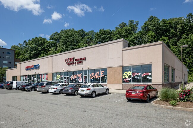
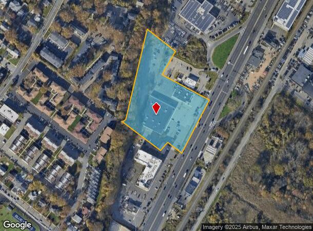
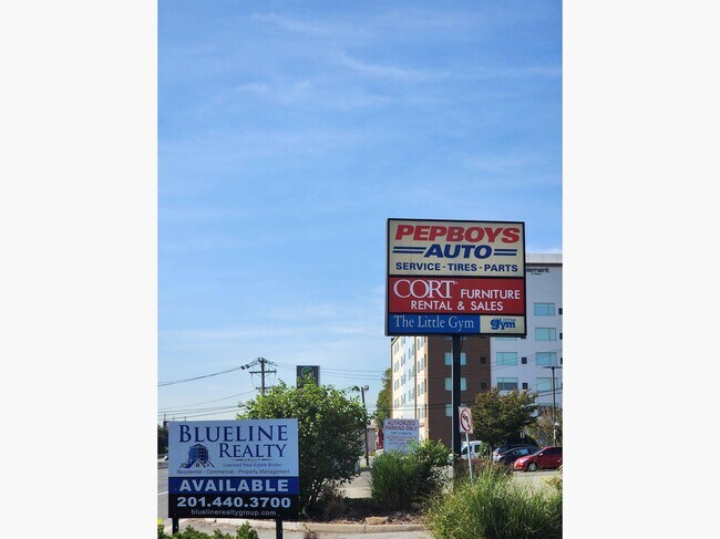
Property Record
5 State Rt 17, Hasbrouck Heights, NJ 07604
NEARBY LISTINGS FOR SALE OR LEASE
Property Detail
5 State Rt 17
New York-Jersey City-White Plains, NY-NJ
4.04
25-00066-01-00013
Bergen
Commercialnec
New Jersey
X
13
34003C0252H
4.04 AC
2024
Route 46 Corridor
2025
Northern New Jersey
025200
DEMOGRAPHICS near 5 State Rt 17
1 Mile
3 Mile
5 Mile
2024 Total Population
17,954
205,553
572,276
2029 Population
17,798
200,657
557,192
Pop Growth 2024-2029
(0.87%)
(2.38%)
(2.64%)
Average Age
42
39
40
2024 Total Households
6,907
74,891
207,497
HH Growth 2024-2029
(0.87%)
(2.39%)
(2.68%)
Median Household Inc
$108,147
$72,695
$80,242
Avg Household Size
2.60
2.60
2.70
2024 Avg HH Vehicles
2.00
1.00
2.00
Median Home Value
$475,977
$446,539
$441,353
Median Year Built
1955
1955
1955
Nearby Places
Map Layers
Map Styles
 Street
 Aerial
- Restaurants
- Banks
- Shops
- Fitness
- Groceries
PUBLIC TRANSPORTATION
COMMUTER RAIL
Wood Ridge (Pascack Valley Line - NJ Transit Commuter Rail (NJ Transit))
DRIVE
WALK
Distance
Wood Ridge (Pascack Valley Line - NJ Transit Commuter Rail (NJ Transit))
4 min
9 min
0.5 mi
Wesmont (Main/Bergen County Line - NJ TRANSIT RAIL, Port Jervis Line - NJ TRANSIT RAIL)
DRIVE
WALK
Distance
Wesmont (Main/Bergen County Line - NJ TRANSIT RAIL, Port Jervis Line - NJ TRANSIT RAIL)
5 min
1.7 mi
AIRPORT
Newark Liberty International
DRIVE
WALK
Distance
Newark Liberty International
18 min
14.3 mi
LaGuardia
DRIVE
WALK
Distance
LaGuardia
31 min
19.5 mi
John F Kennedy International
DRIVE
WALK
Distance
John F Kennedy International
42 min
30.6 mi
Freight Ports
Port Newark Container Terminal
DRIVE
WALK
Distance
Port Newark Container Terminal
25 min
15.9 mi
SALE & LEASE HISTORY
LISTING DATE
SALE/LEASE

Sep 02, 2020
For Lease
Oct 21, 2016
For Lease
Mar 04, 2021
For Lease
Jun 30, 2021
For Lease
Jun 07, 2024
For Lease
Jul 29, 2024
For Lease
Nearby Properties
Address
Land Use
TOTAL SIZE
Lot Size
Zoning
Address
Land Use
TOTAL SIZE
Lot Size
Zoning
Address
Land Use
TOTAL SIZE
Lot Size
Zoning
488,779 SF
7.55 AC
HCS
Address
Land Use
TOTAL SIZE
Lot Size
Zoning
Address
Land Use
TOTAL SIZE
Lot Size
Zoning
4,014 SF
21 AC
Address
Land Use
TOTAL SIZE
Lot Size
Zoning
612 AC
SEA
Address
Land Use
TOTAL SIZE
Lot Size
Zoning
335.71 AC
AF
Address
Land Use
TOTAL SIZE
Lot Size
Zoning
Address
Land Use
TOTAL SIZE
Lot Size
Zoning
Address
Land Use
TOTAL SIZE
Lot Size
Zoning
Address
Land Use
TOTAL SIZE
Lot Size
Zoning
Address
Land Use
TOTAL SIZE
Lot Size
Zoning
Address
Land Use
TOTAL SIZE
Lot Size
Zoning
Address
Land Use
TOTAL SIZE
Lot Size
Zoning
9.57 AC
I2
Address
Land Use
TOTAL SIZE
Lot Size
Zoning
4.37 AC
HCS
Address
Land Use
TOTAL SIZE
Lot Size
Zoning
68.93 AC
Address
Land Use
TOTAL SIZE
Lot Size
Zoning
281,720 SF
3.93 AC
R-3
Address
Land Use
TOTAL SIZE
Lot Size
Zoning
7.10 AC
R-3
Address
Land Use
TOTAL SIZE
Lot Size
Zoning
Address
Land Use
TOTAL SIZE
Lot Size
Zoning
602,220 SF
25.91 AC
Address
Land Use
TOTAL SIZE
Lot Size
Zoning
608,596 SF
27.10 AC
LID
Address
Land Use
TOTAL SIZE
Lot Size
Zoning
30.46 AC
I
Address
Land Use
TOTAL SIZE
Lot Size
Zoning
8.88 AC
ORD
Address
Land Use
TOTAL SIZE
Lot Size
Zoning
261,303 SF
5.60 AC
O
Address
Land Use
TOTAL SIZE
Lot Size
Zoning
8.79 AC
Address
Land Use
TOTAL SIZE
Lot Size
Zoning
4.80 AC
Address
Land Use
TOTAL SIZE
Lot Size
Zoning
394,046 SF
1.88 AC
R3
Address
Land Use
TOTAL SIZE
Lot Size
Zoning
2,191 SF
1.34 AC
B2
Address
Land Use
TOTAL SIZE
Lot Size
Zoning
13 AC
B-3
Address
Land Use
TOTAL SIZE
Lot Size
Zoning
31,896 SF
1.64 AC
O
Address
Land Use
TOTAL SIZE
Lot Size
Zoning
340,218 SF
8.69 AC
B-3
The World's #1 Commercial Real Estate Marketplace
Connect with us
© 2025 CoStar Group
The information above has been obtained from sources believed reliable. While we do not doubt its accuracy we have not verified it and make no guarantee, warranty or representation about it. It is your responsibility to independently confirm its accuracy and completeness. Any projections, opinions, assumptions, or estimates used are for example only and do not represent the current or future performance of the property. The value of this transaction to you depends on tax and other factors which should be evaluated by your tax, financial, and legal advisors. You and your advisors should conduct a careful, independent investigation of the property to determine to your satisfaction the suitability of the property for your needs.